Building the Future of Urban Planning with Digital Twin Technology for Smart Cities

digital twin for smart cities
Services Provided
  • Digital Twin Modeling
  • Real-Time Data Analytics
  • API-Based Connectivity
  • Infrastructure Optimization
  • Urban Planning Solutions
dashboad

The Challenge

Revolutionizing Urban Planning for Smart Cities

A leading urban development company approached us with an ambitious vision: to build a Smart City using Digital Twin Technology that would integrate real-time data and advanced visualization tools to optimize urban infrastructure and services.

Their aim was to create a sustainable and adaptable city model, where urban systems could be managed efficiently through a comprehensive, interactive platform

Key challenges included

City-Wide Data Coordination

Integrating data from various city systems—such as traffic, energy, water, and waste management—into a single, unified platform for easy monitoring and management.

Real-Time Data & Visualization

Developing a solution that would allow city planners to visualize, simulate, and interact with urban environments using advanced 3D models and real-time data.

Urban Resource Optimization

Using predictive analytics to optimize infrastructure and resources such as energy usage, waste collection, and public services.

Scalability for Future Growth

Designing a platform that could easily scale as the city expanded and integrate new technologies as they became available.

Geospatial Data & Land Surveys

The platform needed accurate geospatial data integration to map and manage urban growth, including land surveys, topography, zoning, and more.

infrastructure overview screen

The Solution

A Cutting-Edge Digital Twin Platform for Smart City Management

We developed a Digital Twin of the entire city, using a combination of technologies like AWS, Unreal Engine, Cesium, BIM (Building Information Modeling), Pixel Streaming, and QGIS for geospatial data management. These tools enabled us to create a highly interactive, real-time model of the city that could be used for decision-making, resource optimization, and planning.

Here’s how we implemented the solution:

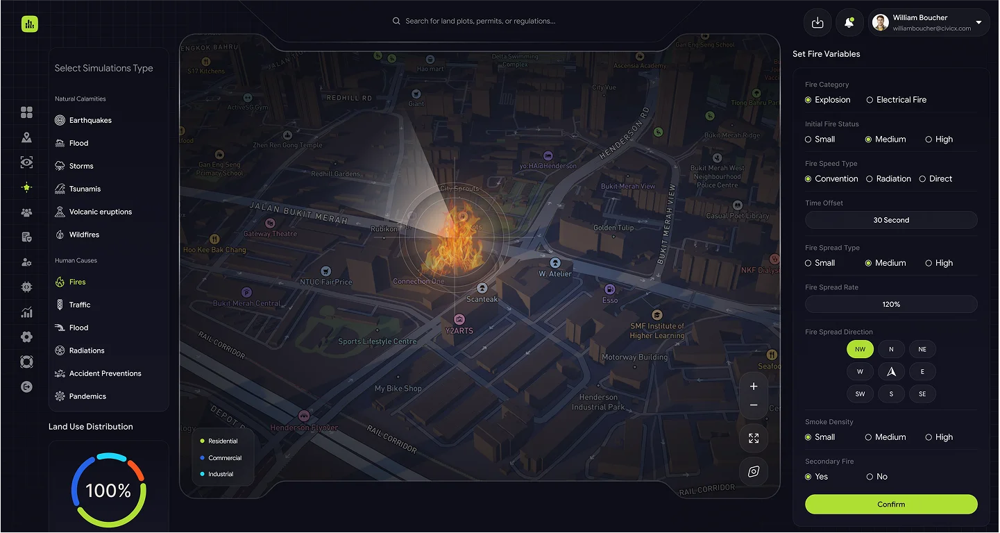
Digital Twin for Real-Time Urban Planning

The Digital Twin model of the city was created using Unreal Engine for high-fidelity, interactive 3D visualization and Cesium for geospatial mapping and rendering. These technologies allowed city planners to visualize and interact with the city in real time, gaining insights into traffic, energy usage, and other urban metrics.

Immersive 3D Visualization

We used Unreal Engine to generate high-quality, photorealistic 3D models of the city’s infrastructure, including buildings, roads, public spaces, and utilities. This enabled real-time interaction, with city planners able to navigate and explore the city as if it were a physical model.

Geospatial Mapping with Cesium

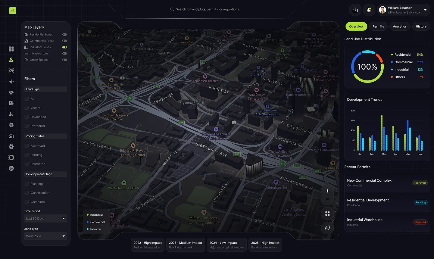
For geospatial data integration, we used Cesium to provide a rich, dynamic 3D map of the city, layering various geospatial data, including land surveys, zoning information, topography, and other geographic data.

Real-Time Simulation

The Digital Twin used real-time data feeds from various urban systems, visualized through Cesium for mapping and Unreal Engine for interactive elements, creating a dynamic simulation of the city.

Geospatial Data Integration and Land Surveying

Accurate geospatial data and land surveying are essential for urban planning. We integrated advanced tools to manage and visualize land surveys, terrain data, and zoning information, allowing city planners to make data-driven decisions.

QGIS for Geospatial Data

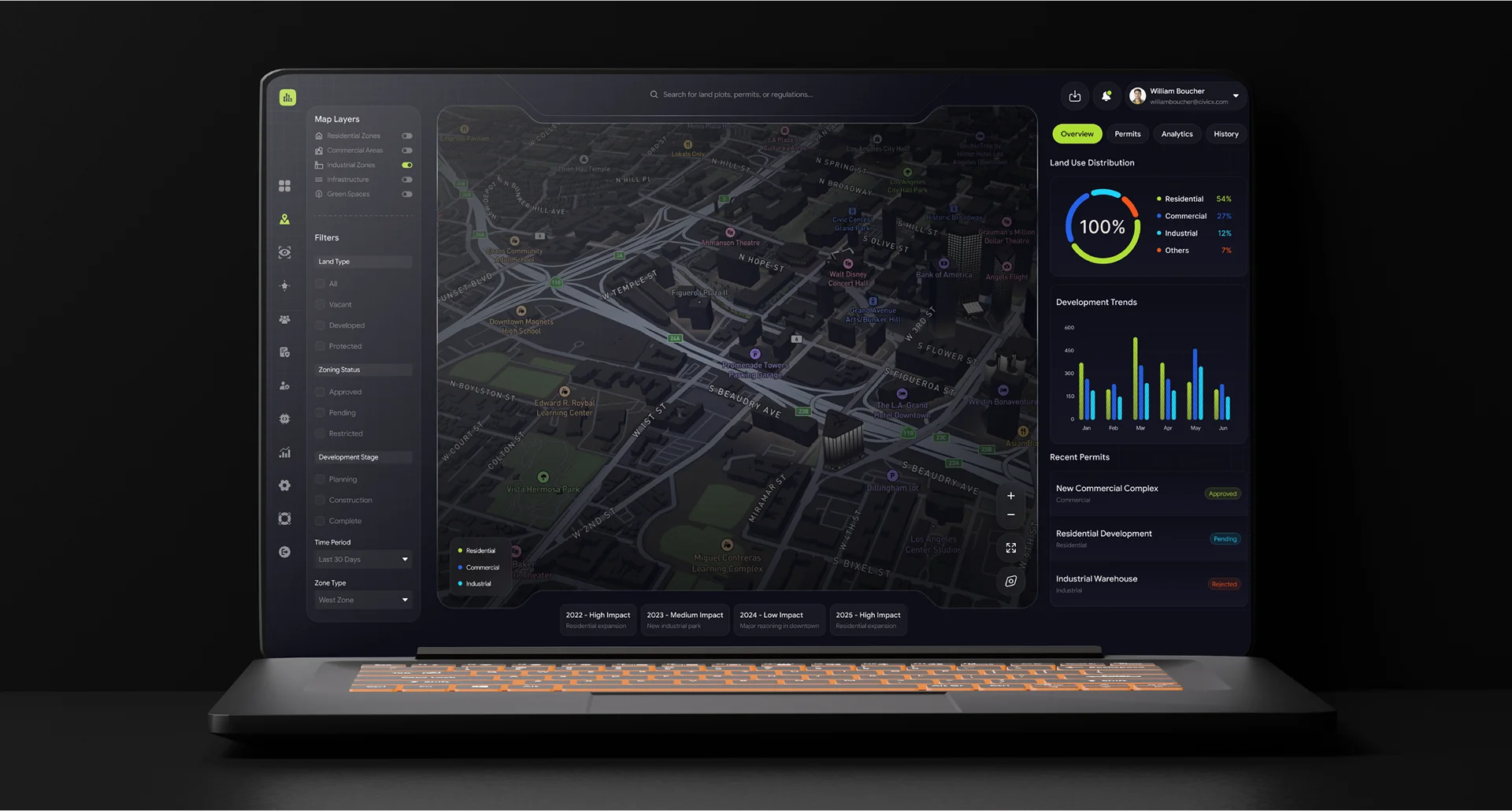
We used QGIS (Quantum GIS), an open-source platform, to handle large-scale geospatial data management, including topographic surveys, zoning maps, and land parcel information. This enabled us to import, process, and visualize data from a variety of sources.

Land Surveys Integration

Using QGIS and Cesium, we integrated detailed land surveys into the Digital Twin, ensuring that every new development and city expansion was mapped with accuracy. This data was used to simulate potential land-use scenarios, including zoning changes, construction planning, and infrastructure development.

GPS and LIDAR

For accurate elevation and spatial data, we utilized GPS and LIDAR (Light Detection and Ranging) technology. This data was processed and integrated into the Digital Twin for highly accurate terrain modeling and infrastructure planning.

city map

API-Based Integration for Seamless Connectivity

The platform was built with API-based integration as a core principle, ensuring seamless data flow from the city’s various urban systems into the Digital Twin. We integrated existing infrastructure and third-party solutions into the platform using standard RESTful APIs to connect and synchronize data.

Data Integration

By connecting traffic management systems, energy grids, waste management tools, and environmental sensors to the platform via APIs, we provided city officials with a unified view of the city's operations, reducing the complexity of managing these systems separately.

Cloud-Based Data Hosting on AWS

The system was deployed on AWS, providing a highly scalable and secure environment to store, process, and manage large volumes of geospatial and urban data. The cloud-based infrastructure ensured that real-time data was accessible and sharable across departments and stakeholders.

Real-Time Analytics and Predictive Insights

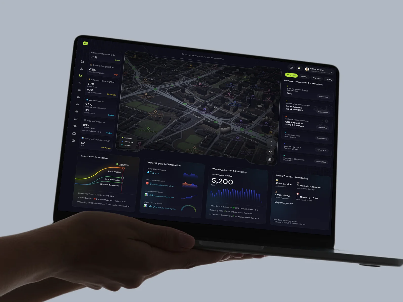
To optimize urban services, we integrated predictive analytics into the platform. This allowed the city to monitor and forecast potential issues in real time, such as energy shortages, traffic congestion, or waste collection inefficiencies. By using advanced tools like Machine Learning (ML) and AI-powered analytics, the system could offer actionable insights.

AI-Powered Forecasting

Machine learning models were used to predict demand for resources (e.g., water, electricity), optimize traffic flow, and identify patterns in urban behavior, helping planners make more informed decisions.

Automated Reporting

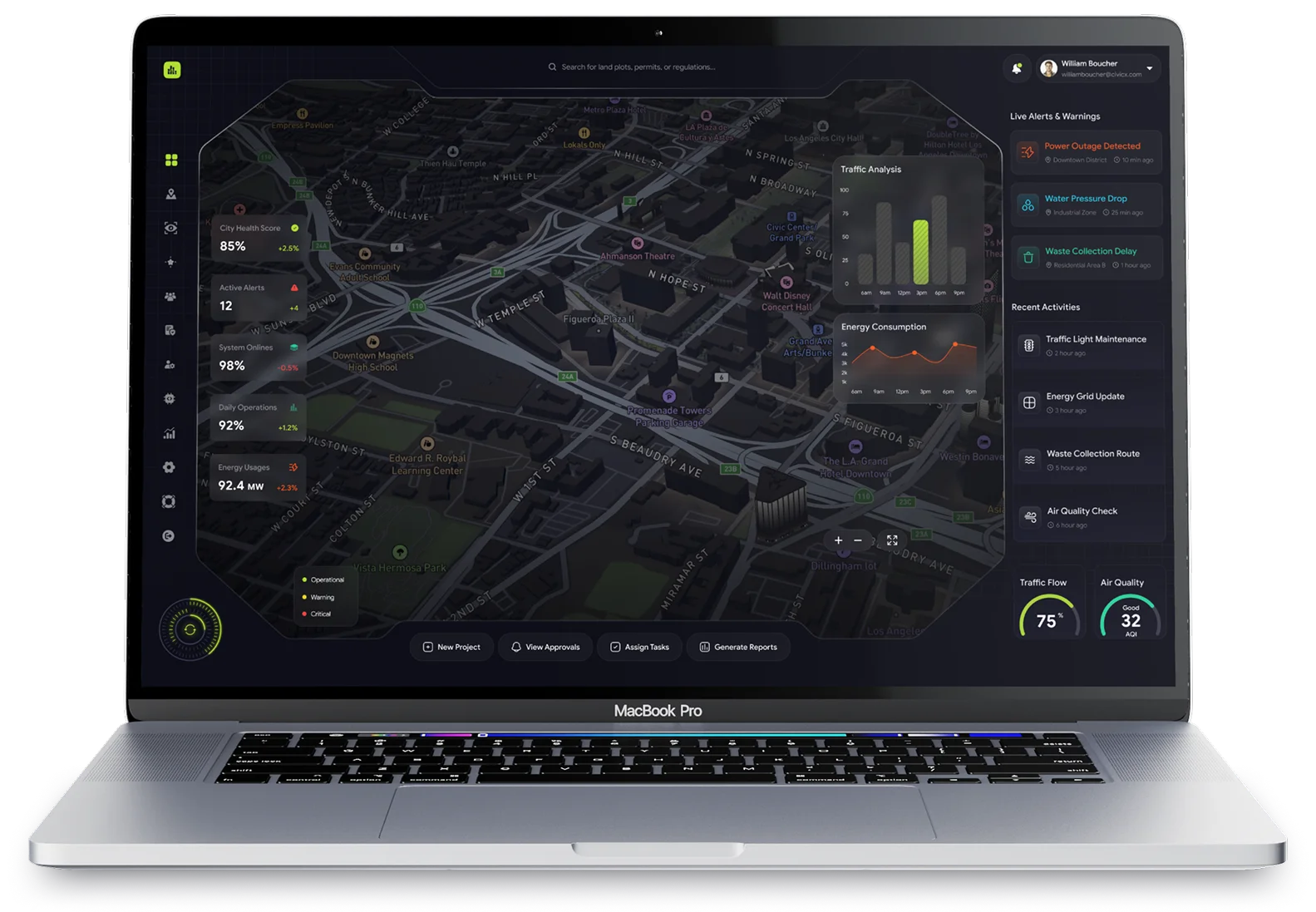
The platform also generated real-time reports on key urban metrics (e.g., traffic congestion, energy consumption) that could be accessed by city officials at any time, reducing the need for manual reporting and increasing operational efficiency.

city map

High-Fidelity, Real-Time Visualization with Pixel Streaming

For an immersive, real-time experience of the Digital Twin, we used Unreal Engine combined with Pixel Streaming. This allowed users to access high-quality, interactive 3D visualizations of the city on any device, without requiring high-end hardware.

Pixel Streaming

With Pixel Streaming technology, we delivered photorealistic 3D visualizations and simulations directly to end-users’ devices—whether desktops, tablets, or mobile phones—without the need for specialized hardware. This made the Digital Twin easily accessible for both technical stakeholders and non-technical users.

Interactive Dashboards

The platform featured interactive dashboards and live visualizations, where users could toggle between different data layers—e.g., energy usage, traffic congestion, waste levels—enhancing decision-making and strategic planning.

fire speed prediction
laptop screen

Scalability for Future Growth

To ensure the platform could scale as the city grew, we relied on cloud-based architecture, utilizing AWS. This allowed for rapid scaling, ensuring the system could manage increasing data volumes, new urban systems, and more complex integrations.

Cloud-Based Infrastructure

With the use of AWS provided the necessary elasticity to scale resources up or down as demand fluctuated, making the system flexible and cost-effective.

Modular Architecture

The platform was designed with a modular architecture, allowing the city to easily add new systems, such as smart traffic lights, autonomous transportation, or environmental sensors, as they were developed.

The Results: A Smarter, More Efficient, and Scalable Urban Ecosystem

The Digital Twin platform revolutionized the urban planning process, delivering measurable results for the client:

optimized operations

Optimized Operations

Real-time insights from Unreal Engine and Pixel Streaming visualizations allowed city planners to optimize traffic flow, energy usage, and waste management, reducing operational costs and improving service delivery.

Data Driven Decision Making

Data-Driven Decision-Making

By integrating AI-powered analytics and real-time data, the platform provided actionable insights that helped city officials plan more effectively, from predicting traffic patterns to managing resources sustainably.

Scalable Growth

Scalable Growth

The platform’s cloud infrastructure ensured that the system could easily scale to accommodate new services, urban systems, and technologies as the city expanded and evolved.

citizen engagement

Citizen Engagement

The ability to stream real-time 3D visualizations to any device using Pixel Streaming allowed for greater public transparency and citizen engagement, fostering trust and participation in city planning.

fire speed prediction

Conclusion: Building the Future of Smart Cities

The Digital Twin platform we developed enabled the urban development company to build a Smart City that is not only optimized but also adaptable to future needs. By leveraging powerful technologies such as Unreal Engine, Pixel Streaming, AWS, Cesium, QGIS, and BIM, we created a platform that empowers city planners to make data-driven decisions, optimize infrastructure, and plan for the future.

For cities looking to revolutionize their infrastructure and optimize urban planning, a Digital Twin platform is an invaluable tool. Our solution helped this client create a connected, scalable, and sustainable city that is better prepared for the challenges of tomorrow.

Ready to build the Smart Cities of the future?

Contact us today to learn how we can help you create a more efficient, sustainable, and connected urban environment with Digital Twin technology.

digital cta